A coalition of states is seeking to avert a U.S. attack, and Israel is in the forefront of their mind.
Michael Young
{
  "authors": [
    "Michael Young"
  ],
  "type": "commentary",
  "blog": "Diwan",
  "centerAffiliationAll": "dc",
  "centers": [
    "Carnegie Endowment for International Peace",
    "Malcolm H. Kerr Carnegie Middle East Center"
  ],
  "collections": [
    "Palestine: The Wars in the War"
  ],
  "englishNewsletterAll": "menaTransitions",
  "nonEnglishNewsletterAll": "",
  "primaryCenter": "Malcolm H. Kerr Carnegie Middle East Center",
  "programAffiliation": "MEP",
  "programs": [
    "Middle East"
  ],
  "projects": [],
  "regions": [
    "Levant",
    "Israel",
    "Palestine",
    "Middle East"
  ],
  "topics": [
    "Political Reform"
  ]
}
Source: Getty
In an interview, Somdeep Sen describes how West Bank settlements, and even Jerusalem’s Hebrew University, have erased the Palestinian presence.
Somdeep Sen is an associate professor at Roskilde University in Denmark. He is the author or co-author of several books, notably Decolonizing Palestine: Hamas Between the Anticolonial and the Postcolonial (Cornell University Press, 2020) and The Palestinian Authority in the West Bank: The Theatrics of Woeful Statecraft (Routledge, 2019). His writings have appeared in the Washington Post, Foreign Policy, the London Review of Books, and other outlets. Sen has conducted extensive fieldwork in the Middle East, including in the Gaza Strip, the West Bank, Israel, Turkey, and Egypt. Diwan interviewed him in early November to discuss with him how landscapes have come to reflect power relations between Israel and the Palestinian population, particularly in the occupied West Bank and Jerusalem.
Michael Young: You are quite interested in how geography and landscapes have shaped the Israeli-Palestinian conflict. Can you explain why that is the case, and in which ways have they done so?
Somdeep Sen: I believe that landscapes are often an exposition of the sociopolitical dynamics of a place—be it the design or planning of a built environment or the way the natural landscape is framed or curated. Israel-Palestine is no different. Israel’s founding involved a central role for geographers, planners, and cartographers who sought to draw up a map of the nation that would transform the symbolic claim to the land into material possession. Palestinian geographers have also played a central role in revealing the history of Palestinian erasure—be it the expulsion of Palestinian communities that happened during the Nakba of 1948 or the ongoing erasure of Palestinian communities in Jerusalem and the West Bank that is happening as a consequence of a militant settlement movement.
In my work, I’m inspired by some of the groundbreaking research that has been done on the spatial design, planning, and securitized political ideology that informs the infrastructure of the Israeli occupation. But my focus is not on the political ideologies that inform this infrastructure. Rather, I am concerned with how this ideology helps determine the way the landscape is experienced. In this sense, I argue that a landscape is not a dead artifact or a passive outcome of a political ideology. Instead, it should be viewed as an active site and source of political meaning-making for those who encounter it in their everyday lives. For settlers, the physicality of the occupation helps normalize and naturalize their sense of sovereign authority over the landscape. For Palestinians, the physicality of the same built environment of the occupation is meant to alienate, interrupt, and undermine their claim to the landscape.
In my research, I conducted extensive ethnographic fieldwork in Israeli settlements as well as Palestinian villages, refugee camps, and towns often located in the vicinity of these settlements. I also conducted fieldwork in Haifa, where I looked at Palestinian homes abandoned during the Nakba, which were now waiting to be engulfed by the urban sprawl of the coastal city. In my current book project, in which I draw on this fieldwork, I also include my (albeit, unplanned and reluctant) encounters with the security infrastructure of the Israeli occupation. And be it through my experience of being routinely stopped, searched, and interrogated at Israeli checkpoints and roadblocks in the occupied West Bank and Jerusalem, or being detained and confined to a small “waiting room” at Ben Gurion Airport, I reflect on the politics of space and place in Israel-Palestine.
MY: One dimension of your field research in Palestinian communities and Israeli settlements has been to examine specifically the design of Israeli settlements. What did you discover, and what have you concluded from your work?
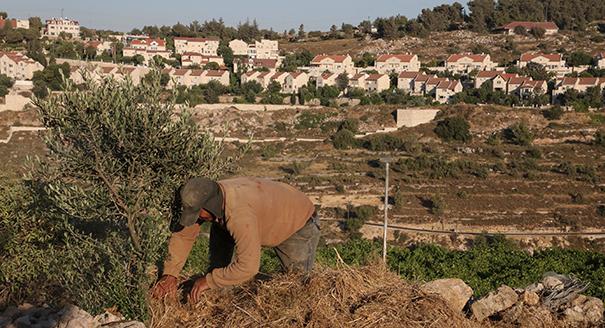
SS: As I mentioned earlier, I am concerned with how the landscape is encountered and experienced. So, with this focus in mind, I conducted ethnographic fieldwork in Israeli settlements to get a sense of the politics written into their design and planning and how this shapes the subjective identity of settlers. The very experience of travelling from Jerusalem to an Israeli settlement such as Efrat is surreal. You are aware that settlements are considered illegal under international law. You know that Palestinian cities and villages are there in the vicinity. But when traveling from Jerusalem you see and feel none of this. You travel on a road on which Palestinians are not allowed to drive. On the highway, barriers and walls block the view of the neighboring Palestinian villages and towns.
The spatial experience within a settlement is similar. Settlements tend to be built on higher ground, and you know that there is a Palestinian village located in the valley below. But you will never see the village. The way the settlements are designed and planned you are only able to see other settlements from the hilltop. When I visited Efrat, on my digital map it seemed as if I was meant to be able to see the neighboring Palestinian village of Wadi al-Nis from certain locations in the settlement. But there were either barriers, walls, or buildings blocking the view or the road simply turned in a different direction. In fact, I had to make a real effort to see Wadi al-Nis, and that was only possible when I trekked all the way to the outskirts of the settlement. Such design aesthetics and politics were a common feature across most settlements. And, in my work, I have argued that it furbishes the settlers’ sense of sovereign authority over the landscape, visually unchallenged by a Palestinian presence. Standing on the hilltop, settlers are able, quite literally, to look over, and therefore overlook, the Palestinians living in their vicinity.
MY: Can you explain what it means that Arabs have been removed from the visual landscape of Israeli settlements, and what settlers told you about this phenomenon?
SS: My sense that Palestinians were purposefully removed from the visual landscape was confirmed during my conversations with settlers. Most settlers that I interviewed took an almost dismissive tone when referring to Palestinian communities in their vicinity—as if to say they weren’t a real community, with a distinct peoplehood, or a people who had any legitimate claim to the land. They deliberately looked away from the Palestinian presence in the landscape. As one of my settler interlocutors said—referring to the de-Palestinized views from the settlement—“We like to maintain peaceful views.”
The absence of Palestinians also reinforced the settlers’ sense of sovereignty and ownership over the landscape. My interlocutors could say, “I don’t think about the Palestinians down there. They want to live here, that’s okay. But they have to remember, [we] are the owners of this land.”
MY: On the Palestinians’ side, how have they reacted to the settlements’ geography and landscape? For example, can you talk to us about Wadi al-Nis, which you mentioned earlier?
SS: When visiting Palestinian villages—especially those located in the vicinity of settlements—one immediately got a sense of fear, as such communities tend to be heavily controlled, monitored, and surveilled by the Israeli military. There is also the physicality of the Israeli hilltop settlement that towers over a Palestinian village. When you live in the valley the settlement tends to dominate the view. So, as a Palestinian you can’t avoid the dominating presence of the settlement in the visual landscape. But despite this, my interlocutors found ways of remaining unaffected and through everyday modes of resilience found ways of reclaiming their right to the occupied landscape.
This was evident to me when I was in Wadi al-Nis. When I asked an elderly Palestinian interlocutor about the village’s relationship with the neighboring settlement of Efrat, he said that there was no relationship: “They stand on top us. They try to control us like this. For them this is their land.” Despite this, he added, “They can think this is all their land. But we know that this is Palestinian land. This is mine. I was born on this land. I grew up on this land. I will die here.” When I then asked about how he dealt with the reality that his land was now occupied by settlers, he replied, “The occupation tries to make this land a prison for us. They prevent our movement. Walls, checkpoints are there to alienate us from our own land. But I walk the land freely, like it’s my own, even when I know the soldiers are watching me. [Pointing to Efrat] I have even climbed that hill. I have been arrested for this. But when I do this, it’s a reminder for them and for me that this is Palestine.” Palestinians in other villages, towns, and refugee camps approached the presence of the settlements in a similar manner and often through mundane everyday tactics found ways of conjuring up an unoccupied space in an occupied landscape.
MY: You also have made an interesting observation that the Hebrew University of Jerusalem, on Mount Scopus, has sought to de-Palestinize the landscape, as you put it. How has it done so, and can you tell us more about the thinking behind the university, which was founded in 1918?
SS: As you rightly point out, the Hebrew University of Jerusalem on Mount Scopus was founded three decades before the establishment of the State of Israel. It served a practical purpose as a place of refuge for Jewish scholars and students who were being systematically expelled from institutions of higher education in Europe. But it was also a marquee Zionist initiative meant to symbolize the revival of the Jewish nation and the reestablishment of the severed connection between a historically persecuted and exiled people and their divinely ordained homeland. You see this symbolism in the design of the campus that, sitting atop Mount Scopus, has unhindered views of the Dome of the Rock—also the location of the Second Temple. In fact, in her book Planning and Building of the Hebrew University, 1919–1948: Facing the Temple Mount, Diana Dolev writes that in the planning stages of the university it was often referred to as the Third Temple. Aesthetically, the original campus was also inspired by Arab architecture, and this was done to ensure that the campus structures seemed indigenous to the surrounding landscape.
Of course, in this narrative—told through the design and planning of the university—there is no recognition of Palestinian existence. In fact, historically, a sense of antagonism toward Palestinians was written into the foundations of Hebrew University. Patrick Geddes and Frank Meyers, who designed the original master plan of the campus, may have appropriated Arab architecture into their vision of the university. But Geddes also wrote, “[A]ny Western eye can see that the Arabs are dirty, untidy, in many ways degenerate, and [are] all too likely to overlook, or have difficulty in seeing, the qualities of their buildings, even those of the fine houses of Damascus type in Jerusalem, with ample courtyards, airy rooms of ample proportions within, and so on.” He then added it was the responsibility of Zionists and the new university to display the utmost potential of Arab architecture through the aesthetics of the new university, with its grand arches and majestic domes.
This antagonism is also on display in the contemporary campus on Mount Scopus—especially since it is dotted with nationalist iconography that proclaims that the university caters primarily to the State of Israel. Walking through the campus, I once came across a sign on a wall dedicated by the American Friends of Hebrew University to members of its Hollywood/Hallandale Chapter, declaring that the Hebrew University is the “university of the Jewish people.” The campus also has several archaeological artifacts that connect the university to Jewish history. The aim is to establish its status as an institution that contributes to the renewal of Jewish heritage. Naturally, Palestinian students feel alienated by the Israeli-ness of the campus and by what they consider to be an attempt to de-Palestinize a landscape that they consider integral to the Palestinian national territorial home.
The politics of the hilltop campus is equally reflected in the way it physically towers over the neighboring Palestinian communities, and allows those looking out from the campus to overlook the Palestinian presence in the area. You see this with the neighboring village of Issawiya, located in the valley on the eastern edge of the university campus, which has come to symbolize the disparity that exists between Israeli and Palestinian spaces. The well-maintained and carefully curated aesthetics of the campus stand in stark contrast to Issawiya’s congested and garbage-filled alleyways that are neglected by the Jerusalem municipality. For more than a decade, vehicles from Issawiya have not been allowed to drive out of the village in the direction of Mount Scopus because of an army checkpoint. Also, Palestinian students and the university’s contractual workers from Issawiya are often searched by the police at the checkpoint before they are allowed to enter the campus.
For my interlocutors from Issawiya, however, much of what the campus does to the neighboring Palestinian communities is also reflected in the way the village, quite literally, lives in its shadow. In May 2016 a Palestinian student, Sara, a resident of Issawiya, gave me a tour of the village. We were walking along the edge of the village that borders the university when she said, “Issawiya is my home.” Then she stopped abruptly to look up in the direction of the campus and continued, “But if you look at the campus it stands above us. From Issawiya we have to look up to the campus on Mount Scopus. This means we look up, but they look down on us. This is the historic relationship we have with Hebrew University. It’s a relationship between the colonizer and us. The goal is to make us disappear.”
This relationship is most evident in the views from the Jack, Joseph, and Morton Mandel School for Advance Studies in the Humanities, located only a few meters from the campus fence that separates Hebrew University from Issawiya. When I walked through its main entrance in December 2015, Issawiya dominated the view from the floor-to-ceiling windows at the Mandel School. But when I sat down in the lounge located on the floor below the entrance, the Palestinian village descended to the periphery of my view and I could choose to overlook it. It was almost as if the view from the Mandel School was designed to simulate Palestinian absence.
Surprised by how easily Issawiya disappeared from landscape, I asked an Israeli student, who was sitting in the lounge at the time of my visit, about the view from the Mandel School. She said, “I consider myself a left-wing person and when I look down, I see the Palestinians and what the occupation does to people in Issawiya. There is no steady water supply. There are piles of trash. But if you sit here and look out you can easily ignore Issawiya.” I then asked her, “Do you think this place was built like this on purpose so that Palestinians would disappear when we look out from here?” She replied, “In a way. Sitting up here you can pretend that Palestinians don’t exist. When the donors came to inaugurate this building, they told us to sit here and enjoy the views of the Judean desert and did not mention the Palestinians.”
That this view—one that allows one to overlook the Palestinian village in favor of the far more “benign” Judean desert on the horizon—serves its purpose was apparent during a conversation I had with another Israeli student who was smoking on the balcony of the Mandel School. When I asked him about Issawiya and its relationship with the campus, he said, “That’s an Arab neighborhood. It’s a problem area. We don’t have too much to do with them.” He then added, “But the good thing is at night you can’t see it. The view of the desert in the dark is quite nice.”
Carnegie does not take institutional positions on public policy issues; the views represented herein are those of the author(s) and do not necessarily reflect the views of Carnegie, its staff, or its trustees.
A coalition of states is seeking to avert a U.S. attack, and Israel is in the forefront of their mind.

Michael Young
A recent offensive by Damascus and the Kurds’ abandonment by Arab allies have left a sense of betrayal.
Wladimir van Wilgenburg
Implementing Phase 2 of Trump’s plan for the territory only makes sense if all in Phase 1 is implemented.

Yezid Sayigh
Israeli-Lebanese talks have stalled, and the reason is that the United States and Israel want to impose normalization.

Michael Young
The government’s gains in the northwest will have an echo nationally, but will they alter Israeli calculations?

Armenak Tokmajyan