Commentary
Syria's transition promised a fresh start. But are old habits of power making a comeback? This analysis looks at the warning signs and what it will take to build a more accountable state.
Sima Beitinjaneh
{
  "authors": [
    "Sarah Al-Kbat"
  ],
  "type": "commentary",
  "blog": "Sada",
  "centerAffiliationAll": "dc",
  "centers": [
    "Carnegie Endowment for International Peace"
  ],
  "englishNewsletterAll": "menaTransitions",
  "nonEnglishNewsletterAll": "",
  "primaryCenter": "Carnegie Endowment for International Peace",
  "programAffiliation": "MEP",
  "programs": [
    "Middle East"
  ],
  "projects": [],
  "regions": [
    "Yemen",
    "Middle East"
  ],
  "topics": [
    "Political Reform"
  ]
}
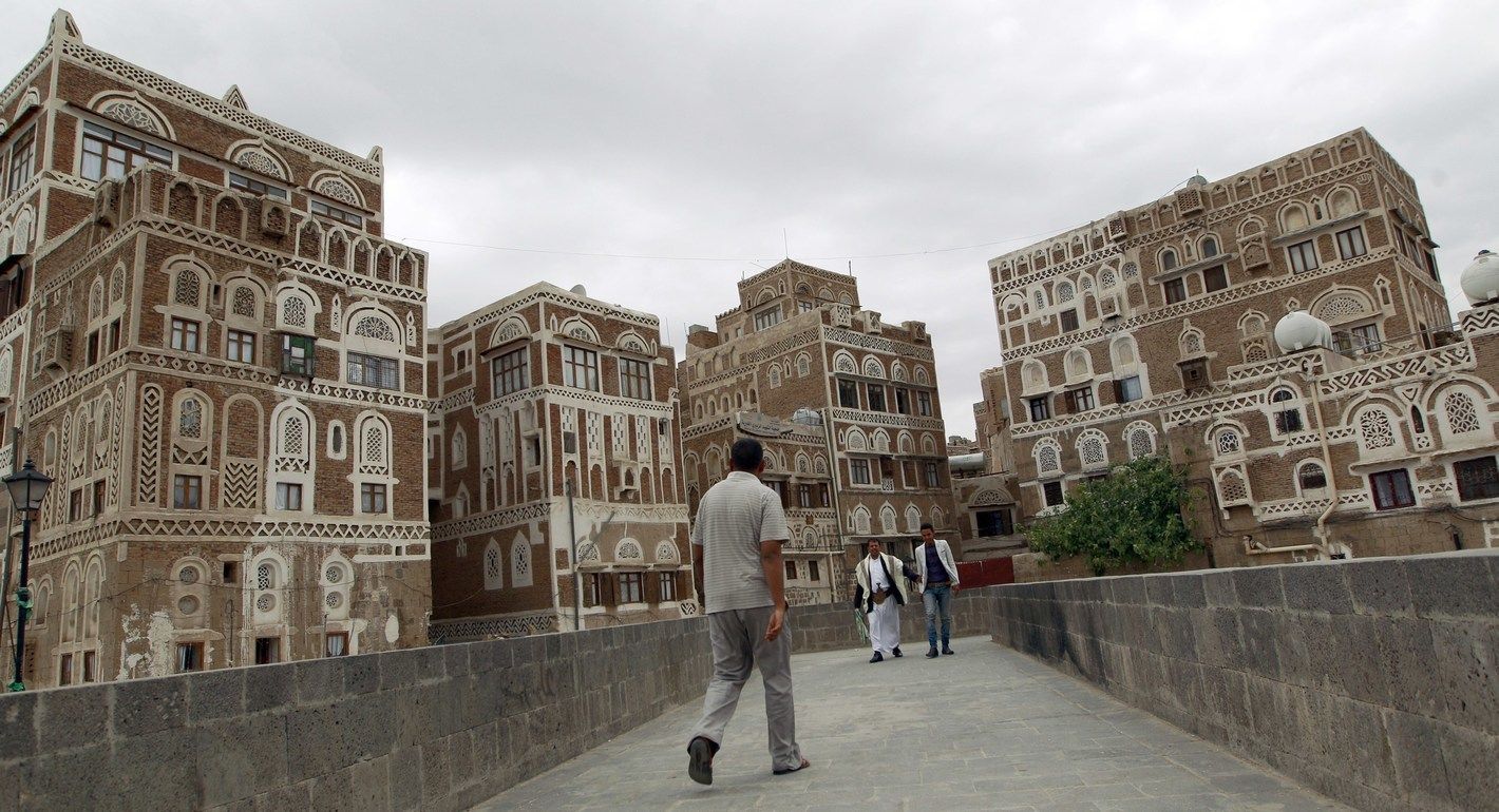
Source: MOHAMMED HUWAIS/AFP via Getty Images
The chaos of street naming in Sana’a reflects the deep weakness of the Yemeni state and its failure to establish a unified urban identity, leaving residents to rely on informal, oral naming systems rooted in collective memory. This urban disorder is not merely a logistical problem but a symbolic struggle between state authority and local community identity.
Sana’a is the political and administrative capital of Yemen and one of the country’s most important cultural centers. With origins dating back to the second century AD, it stands among the oldest continuously inhabited cities in the world. Yet, compared to other Arab capitals such as Cairo or Beirut, the Yemeni capital suffers from a profound urban and civic identity crisis—one shaped by successive waves of political and military turmoil, widespread violence, and the near-total collapse of state institutions.
While major Arab cities have made concerted efforts to modernize their address systems—shifting from informal, descriptive methods to standardized digital frameworks that enable accurate navigation and structured urban planning— Sana’a remains trapped in an urban landscape shaped largely by protracted conflict and political fragmentation.
The long years of war and governmental disarray have weighed heavily on Sana’a, derailing urban planning initiatives, dismantling standardized development efforts, and severely undermining the state’s ability to oversee and regulate the urban environment. Yet despite this institutional erosion, the historic core of Sana’a has retained key elements of its architectural identity—evident in its distinctive mud-brick buildings, bustling traditional markets, and densely interwoven neighborhoods.
However, the roots of Sana’a’s current urban challenges can be traced back to 1962, following the establishment of the republican system. During this period, the city experienced rapid urban expansion, driven by waves of internal migration from rural areas as people sought better economic and social opportunities. While this influx transformed Sana’a into a microcosm of Yemen’s social and cultural diversity, it also overwhelmed the city's capacity for effective planning and service delivery, resulting in fragile infrastructure and strained urban management systems.
These structural weaknesses became particularly evident in the city’s address system—or lack thereof. In a landscape of largely indistinguishable neighborhoods and winding alleys, and in the absence of a coherent numbering scheme, locating an address can be a daunting task. Many streets bear official names that are rarely used, while others are known only by colloquial or unofficial titles. In numerous cases, there are no signs at all, leaving entire areas effectively unmarked and disorienting for residents and visitors alike.
This confusion is not simply the result of a circumstantial administrative oversight; it reflects a deeper crisis in the relationship between the state and society. The absence of a coherent addressing system signals the state’s failure to assert its symbolic and organizational presence in urban space. It also reveals a hidden tension between centralized authority and the spatial memory of the local community.
Despite Sana'a’s continued physical expansion, most of its neighborhoods still lack a unified numbering or address system. This absence hinders mobility and delivery services, forcing residents to rely on oral directions and familiar landmarks as substitutes. As a result, while Sana'a may appear to be urbanizing on the surface, it is in fact descending into a form of spatial disorder—one that reflects the Yemeni state’s chronic inability to organize public space amid persistent political turmoil and repeated cycles of violence.
This article explores the extent to which the disorder in Sana'a’s street labeling reflects the weakness of central authority. It also considers what customary naming practices reveal about the collective consciousness and cultural orientations of society. Ultimately, it asks whether this duality can be interpreted as a symbolic conflict between the state’s project and that of the community—or the city itself.
In an interview, Abdullah Mohammed,1 a Yemeni man in his forties, recounted his experience trying to locate a wedding hall in Sana'a where he was to attend a family event. Aware that the address alone would be of little help, he turned to the internet to find the hall’s phone number. When he contacted the owner, he was simply told that the hall was “near the Military Academy.”
Mohammed proceeded to the general area but was surprised to find that none of the passersby or nearby shopkeepers recognized the hall’s name or location. After wandering the vicinity in vain, he called the owner again. This time, the owner offered a brief set of oral directions: “Go straight, you’ll see a large supermarket. Take the street behind it, then there’s a side road, and then a red building—there you’ll find the hall.”
Reflecting on the ordeal, Mohammed expressed his frustration: “There is no way to reach anywhere in Sana'a except like this—through spoken directions and landmarks known only to locals.”
This story reflects the daily struggle faced by thousands in the Yemeni capital, where the absence of a standardized naming and numbering system remains one of the most visible symptoms of urban disorder. The consequences go far beyond individual inconvenience. Basic services are also affected. For example, taxi drivers in Sana'a rely almost entirely on their personal familiarity with the city and on the verbal directions provided by passengers.
In another interview, a local driver named Amr explained:2 “Sometimes I refuse delivery requests to certain neighborhoods—especially at night—because I know I’ll spend a long time searching for the location, and I might not even find it. It’s exhausting and a waste of time and fuel.” He added that the situation is even more dangerous for emergency services like ambulances or civil defense units, where delays in locating an address can have life-threatening consequences. “I’ve often had customers describe locations in strange ways,” he said. “They’ll say something like, ‘I’m at the big tree near the grocery store next to the small mosque,’ or ‘I’m by the red building on the roundabout next to the old parked car.’”
These improvisational methods of navigation are so ingrained in daily life that they rarely draw attention or concern among Sana'a’s residents. They seem normal—unless compared with the systems of urban organization, infrastructure, and state presence experienced in more centralized and developed contexts outside Yemen.
Street labels are not merely spatial identifiers—they represent the state’s vision and serve as expressions of a city's cultural and historical identity. They reveal power dynamics and the degree of societal engagement with state authority. As the primary organizer of urban space, the modern state typically seeks to impose unified standards to regulate public space—controlling not only street planning, but also architectural forms, color schemes, and the visual identity of the city.
The French sociologist Pierre Bourdieu refers to this as the “power of naming,”3 a form of symbolic control that lies at the heart of the struggle between individuals and the state. In centralized spaces, the authority to name carries symbolic capital and reflects broader political hierarchies. Similarly, in his influential book Seeing Like a State, American political scientist James C. Scott argues that naming streets is a deeply political act—an effort by the state to render space legible and governable on its own terms, rather than through the local knowledge of its inhabitants.
In contrast, customary nomenclature emerges from people’s lived experiences, reflecting local histories, spatial habits, and everyday needs. As James C. Scott writes, “The naming mechanism works efficiently, encrypting local knowledge, and including in the name the most important information one needs to know about this route.”
According to Scott, official state designations aim to produce a “top-down readable” city—characterized by standardized names and uniform classifications—whereas popular naming practices, though difficult to manage within bureaucratic systems, allow for repetition, variation, and contextual relevance, making them highly functional at the local level.
Scott argues that pre-modern states were largely “blind” to the intricate details of the societies they governed due to the absence of standardized information and naming systems. This lack of legibility, he suggests, often served as a form of indirect resistance to central authority. The modern state’s project, by contrast, has been to eliminate this ambiguity by transforming informal, localized knowledge into legible, controllable systems—through mechanisms such as censuses, standardized toponymy, real estate registries, and the recruitment of local intermediaries to access and reshape insular social structures.
Within this theoretical framework, Sana'a can be seen as the antithesis of the “readable” state envisioned by Scott. It is a city that resists statistical legibility, lacks coherent urban organization, and is marked by unregulated expansion, chaotic street labeling, address ambiguity, and overlapping urban influences.
Examining the city’s informal and customary labels provides insight into the nature of social life in Sana'a, its historical evolution, and the population’s complex relationship with the state. These labels are not merely functional—they carry symbolic weight, reflecting a deeper tension between top-down impositions and grassroots naming practices circulating in the streets.
As in most Yemeni cities, Sana’a exhibits a duality in its street names, where official designations issued by government agencies coexist—and often clash—with locally used names rooted in everyday experience. This duality is not merely a matter of administrative inconsistency; it reflects the fragility of state authority, the complexity of urban identity, and an ongoing symbolic struggle over space and memory.
Historically, until the 1960s, Sana’a was a small town enclosed within its ancient walls, home to roughly 50,000 to 60,000 residents. Today, it has grown into a sprawling metropolis covering approximately 390 square kilometers and accommodating over three million people from across Yemen. This dramatic transformation in both population and urban scale was driven largely by the political upheaval of 1962, which ushered in a wave of modernization and triggered mass rural migration to the capital.
However, this urban expansion was not accompanied by comprehensive planning. The result was the proliferation of informal settlements and a persistent vacuum in both street planning and naming systems. Efforts by Amanat Al-Asimah, the capital’s administrative authority, to impose order have been sporadic and largely ineffective. In 2002, a citywide street naming and numbering initiative was launched but quickly collapsed. A renewed attempt in 2010 also failed to yield tangible results due to poor coordination between regions, the absence of a unified urban vision, and chronic resource constraints.
In his article "The Challenges of Urban Transition in Yemen: Sana’a and Other Major Cities", researcher Roman Stadnicki highlights a striking paradox: Yemen, while being the most densely populated country on the Arabian Peninsula with a population of approximately 25 million, remains the least urbanized. Only one in three Yemenis currently resides in a city—an increase from just one in four in 1994—despite rapid demographic growth. Stadnicki characterizes this phenomenon as an “urban splash,” a term he uses to describe the fragmented and often unstructured urban expansion that has been unfolding since the 1970s, driven by population pressures and rural-to-urban displacement.
This transitional phase from rural to urban life demands profound political, economic, and social transformation. But what Sana’a is currently experiencing is a phenomenon called “faltering “or “incomplete” transition. The city’s growth is marked by unregulated sprawl, a fragmented urban fabric, and a chaotic landscape of street and neighborhood names. The clash between customary (popular) and official (state-imposed) designations reveals not only the limited capacity of state institutions to assert authority over urban space, but also the enduring influence of local traditions and social norms. Despite successive government efforts to implement names aligned with national development agendas, traditional labels remain deeply rooted, resulting in administrative disarray and a lack of coherent urban planning—disruptions that reverberate through daily life in the capital.
Street names in Sana’a illustrate the city’s history and its deep ties to popular memory, often overriding official designations imposed by the state. A prominent example is "Hayel Street," which continues to be known by its original name among residents, despite state efforts to rename it “Riyadh Street.”
This loyalty to popular naming reflects the enduring dominance of informal labels, which are deeply rooted in personal identity and collective memory. Historic neighborhood names such as Al-Hasaba, Hadda, and Beit Boss have persisted, even as the urban landscape around them has evolved. Likewise, many of Sana’a’s roundabouts—locally known as jawlat—carry the names of prominent families or influential figures, such as Al-Dhubaibi, Al-Ruwaishan, and Al-Habari. While unofficial, these names reflect the social status and real estate influence of the families they represent, and over time, have become firmly embedded in the city’s public consciousness.
Some street names also reflect the geographic origins of their residents—such as "Taiz Street" or "Marib Street"—serving as evidence of people's continued attachment to their hometowns and villages, even after relocating to the capital. In contrast, since the establishment of the republic, the state has adopted a more systematic approach to street naming, using titles linked to official institutions—such as Al-Ziraa (Agriculture) Street, Al-Adl (Justice) Street, and Al-Qiyadah (Command) Street—in an effort to assert state authority and embed its logic into the civic fabric.
Street names based on prominent landmarks—such as Sheraton Street—have also emerged, illustrating how the modern economic landscape contributes to shaping the city’s collective memory. Following the September 26, 1962, revolution, the state expanded its naming strategy to include national symbols, assigning names like Al-Zubairi Street, Tahrir, Gamal Abdel Nasser, and Ali Abdel Moghni to major roads as part of an effort to construct a civic republican identity.
However, the state’s presence remained limited when it came to enforcing official street names. An example is former President Ali Abdullah Saleh, who, despite his long tenure, never had a street named after him. At the same time, names rooted in natural landmarks—such as Bir al-Azab and Bir al-Salam—persisted, reflecting the city's historical heritage and its ancient environmental and social foundations.
In recent years, Amanat Al-Asimah has attempted to rename several streets in tribute to prominent historic and national figures— for example, renaming Al-Khamseen Street to “The Great Prophet,” Southern Sixty to “Martyr Ibrahim Al-Hamdi,” and Western Ring Road to “Poet Abdullah Al-Bardouni.” However, these efforts have largely faltered due to the lack of legitimacy of the de facto authority controlling Sana’a since 2015, along with sever resource constraints brought on by the protracted civil war. As a result, many of these official names remain ink on paper, while residents persist in using street names that resonate more deeply with their identity, culture, and daily experiences.
The study of street naming in Sana’a reveals that place-naming is not merely an administrative act, but a social and cultural process shaped by the relationship between people and space. It also exposes the ongoing contest between state authority and society in assigning symbolic meaning to the urban landscape. On one hand, the coexistence of overlapping and often conflicting names reflects the weakness of the central government and its inability to impose a unified symbolic order—an erosion of influence in one of the most basic expressions of urban governance. On the other hand, the endurance of customary names highlights the vitality of collective memory and social identity, where families, local figures, and everyday life leave lasting marks on the city’s map.
This overlap and tension between official and popular naming represent a symbolic struggle over space and meaning, where the state and society compete to define the identity and significance of the city. While the state aims to consolidate its authority by imposing formal names, local communities resist by preserving and circulating customary labels that carry their own meanings and attachments that challenge the official narrative.
It is also important to note that several main streets in Sana’a and other Yemeni cities are named after various Arab countries and cities—such as Algeria, Beirut, Amman, Tunisia, Mogadishu, Nouakchott, Rabat, and Benin. These names were introduced during specific periods as expressions of political solidarity or diplomatic ties, reflecting the nationalist discourse prevalent at the time. However, despite their inclusion in official urban plans, many of these names lacked local relevance and failed to resonate broadly with residents. As a result, some have gradually fallen out of everyday use, overshadowed by customary names that have deeper social and cultural significance to the local communities.
Despite its relatively small size compared to many capitals and cities worldwide, Sana’a’s streets form a complex maze—difficult to navigate and understand, especially for visitors or newcomers.
This challenge stems not only from the city’s irregular geography but, more critically, from the chaotic nature of its urban planning and street naming. The spatial disorder that defines much of Sana’a today reflects a deeper dysfunction: the fragmentation and weakening of the state’s authority.
With no unified central government and a protracted ongoing conflict, efforts to organize and standardize street names have been repeatedly postponed or deprioritized. This has further complicated the urban landscape, especially as suburban expansion continues and new streets emerge without clear regulation or oversight.
The war has shifted the priorities of the Yemeni competing authorities in Sana’a and Aden away from long-term urban development projects that require stability and planning, effectively ending the already modest planning efforts of earlier decades. As various factions assume control over different parts of the city, each implements its own naming policies- or leave the task to informal, customary initiatives.
Addressing this urban crisis requires more than piecemeal reforms or administrative fixes, particularly because it is inseparable from the broader political dynamics of the Yemeni conflict. A sustainable solution must begin with the restoration of a unified and legitimate central authority capable of regulating civilian life—including urban planning and spatial designation.
This should be paired with a forward-looking symbolic strategy for the city—one that transcends current divisions and combines the city’s historical memory with a modern, organized vision.
Engaging local communities and experts in the naming process is crucial to ensure broad acceptance and societal consensus. Additionally, launching inclusive and well-planned urban development initiatives can reestablish planning as a cornerstone of identity-formation and help rebuild a shared sense of belonging in a city that continues to search for coherence amidst fragmentation.
Sarah Al-Kbat
Sarah Al-Kbat is a journalist and fact-checker with a bachelor's degree from the Faculty of Mass Communication at Sana'a University in Yemen and a master's degree in media studies from Necmettin Erbakan University in Turkey.
Carnegie does not take institutional positions on public policy issues; the views represented herein are those of the author(s) and do not necessarily reflect the views of Carnegie, its staff, or its trustees.

Syria's transition promised a fresh start. But are old habits of power making a comeback? This analysis looks at the warning signs and what it will take to build a more accountable state.

Sima Beitinjaneh
Syria’s worsening drought is no longer a seasonal crisis. This report explains what climate change is doing to rainfall, groundwater, and food security, and what solutions experts say are still possible.

Milia Esper
From anime heroes to online gaming communities, Morocco’s Gen Z is building a new protest culture. What does this digital imagination reveal about youth politics, and how should institutions respond?
Abdelilah Farah

In a volatile Middle East, the Omani port of Duqm offers stability, neutrality, and opportunity. Could this hidden port become the ultimate safe harbor for global trade?
Giorgio Cafiero, Samuel Ramani
Is Morocco’s migration policy protecting Sub-Saharan African migrants or managing them for political and security ends? This article unpacks the gaps, the risks, and the paths toward real rights-based integration.
Soufiane Elgoumri