Commentary
As negotiations with Iran and Lebanon continue, chaos is at the heart of the Netanyahu government’s calculations.
Michael Young
Source: Getty
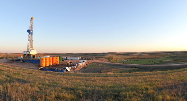
An oil production boom in the Northern Great Plains is threatening the region’s water resources. Comprehensive management is needed to mitigate the risks.
The Northern Great Plains has become the epicenter of new oil development in the United States. New production techniques have set off an oil boom there reminiscent of the chaotic conditions over a century ago when the prospect of black gold drew developers to Texas. Water impacts were not remotely a consideration back then. But now, unprecedented levels of drilling in this huge oil basin require the implementation of careful water management practices to protect regional resources.
Drilling takes place throughout the Great Plains’ Williston oil basin, home to the Bakken, Three Forks, and Tyler formations, reaching into the U.S. states of North Dakota, South Dakota,1 and Montana as well as Canada’s provinces of Saskatchewan and Alberta. With an estimated 7.4 billion barrels of technically recoverable oil in the United States (plus an additional 1.6 billion barrels in Canada), the Williston basin is the largest continuous oil accumulation in the country.
It is also one of the world’s most rapidly and densely developed oil plays with about 8,000 still-active wells drilled between 2006 and 2014. The United States Geological Survey (USGS) estimates that five times that number will be needed to access the total technically recoverable oil. But plans to continue producing at this rate will pose severe oil-water risks in the area.
The region’s geology and history convey unique water challenges, quite different from those in other U.S. shale formations. The sheer number of wells needed to produce the Williston creates a huge demand on freshwater for drilling, hydraulic fracturing, and maintenance. Along with oil, produced water (wastewater produced as a byproduct during oil production) is brought to the surface through these wells. Produced water yields are correlated to oil yields, so as the Williston basin’s oil production increases, produced water quantities and the associated contamination risks and disposal needs will accumulate. Further complicating the freshwater quantity demands and wastewater contamination concerns, a mosaic of state, national, and tribal borders provides potential for irregular data reporting, insufficient regulatory oversight, inconsistent rules, and inadequate contamination cleanup.
If the Williston basin is going to help supply America’s oil needs over the long term, the Northern Great Plains’ oil-water challenges must be adequately controlled and safely managed.
The Williston’s shale is relatively easy to navigate. Overlapping formations allow oil companies to extract the oil with great speed and success.
The Bakken, while it has limited amounts of conventionally pooled oil, is almost completely an unconventional shale oil play. It is comprised of three informal layers: the upper, middle, and lower. Directly beneath the Bakken lies the Three Forks formation.2 Three Forks 1, the shallowest of the formation’s four main layers, has been produced in conjunction with the Bakken for many years. Recently, however, oil companies have begun to explore some of the deeper layers, allowing them to produce at multiple depths from the same plot of land, gaining access to more oil without acquiring more land. The Tyler formation, which is much shallower than the Bakken and Three Forks formations, is located farther south, and its unconventional oil potential is just beginning to be explored.
The Bakken formation was first identified in the early 1950s, though production was initially quite slow. That changed with the advent of hydraulic fracturing—the process of injecting a high-pressure slurry of chemicals, water, and propping agents to break apart shale and allow hydrocarbons to flow out of rock formations. Innovations in this technique transformed North Dakota’s oil operations.
Since 2006, oil production has expanded exponentially into the Bakken, Three Forks, and Tyler formations along with other smaller, lesser-known formations in the area (see map). Recently, drilling horizontally to produce oil in the Tyler formation has begun though it is still uncertain if the Tyler formation will be able to transition from a somewhat successful conventional play (accessed by vertical drilling) into a strong continuous play, produced by replicating new techniques used in the Bakken.


The Williston basin yielded over 1 million barrels of oil per day in early 2014, and, according to state databases,3 an average of over 600,000 barrels per day of wastewater were produced in March 2014 in Montana and North Dakota in the Bakken, Three Forks, and Tyler formations alone.4 However, future increases in oil production will come at the cost of greater water demands and water production.
Companies aim to further reduce the space between wells to maximize access to oils at different depths from the same acreage. Leases that had only one well before may now have up to eight. As seen in Kodiak Oil & Gas Corp’s, Continental Resources Inc.’s, and other companies’ plans, there could be 14–34 wells per 1,280 acre lease.5 Wells are drilled and fracked more quickly and more cheaply as technology advances allowing companies to expand and increase their water demands rapidly.
The drilling process demands some water, but the hydraulic fracturing process and the water used to clean the well over its lifetime account for most of the water consumed during oil extraction. A single well fracking in the Williston averages 2 million gallons of water. Refracking wells two to three times, which is now common practice in the Williston, demands proportionately more freshwater than one-time fracking seen in other basins. And while some of the water used to clean wells can be reused as the base fluid for new fracking projects, new freshwater is required for each maintenance flush.
With so much freshwater required to boost oil production, the question is: Where will the water come from? A range of resources can be found in the Northern Great Plains’ geology, including bedrock aquifers at many depths, glacial aquifers, the Missouri River winding through Montana and North Dakota, and Lake Sakakawea, a reservoir on the Missouri. These water resources vary markedly, and their characteristics must be used to determine how much water and which water the states can afford to permit oil companies to acquire, directly and indirectly.6
Making the situation more complicated, while the area may have ample water supplies, many rural citizens do not have secure access to them. The region currently struggles with fresh groundwater scarcity, low precipitation, minimal water infrastructure making transporting water extremely difficult, and federal restrictions regarding the use of the Missouri River and Lake Sakakawea as surface water sources.
Confined bedrock aquifers of varying water quality underlie the Williston basin, some of which are artesian aquifers that flow to the surface without the need for electrical pumps, a boon in remote locations that must be protected.
The slightly saline Fox Hills–Hell Creek aquifer (noted with diagonal orange lines on the map) is the only groundwater source capable of consistently producing large amounts of freshwater. As a result, it is overdrawn. Although rarely a drinking water source because of its relatively high concentration of total dissolved solids, (2,500 milligrams per liter), it is a major source for industrial, livestock, and residential use.7
Overuse has caused rapid long-term reduction in aquifer pressure by 1 to 2 feet per year. As a result, some of the artesian wells drawing from the Fox Hills–Hell Creek aquifer have stopped flowing and more will dry up in the future. Using this aquifer solely for domestic and livestock purposes and forcing industry to find other sources of water has been discussed, but stronger action may be needed.
Glacial aquifers, formed as glaciers melted and receded leaving permeable sediment behind, can be found in drainage system patterns throughout North Dakota and Montana. These aquifers, usually less than a few hundred feet deep, can be much more productive than bedrock aquifers, often with lower total dissolved solids concentrations. Their high flow rates mean water spends shorter times within the aquifer dissolving and accumulating salts and minerals. Thus, these aquifers often tend to be the only source of irrigation-quality groundwater in the area. High flow rates, however, lead to difficulty managing the resource, as discharge can happen quickly while recharge rates are variable and uncertain.
The most reliable sources of surface water in the area are the Missouri River and its reservoir, Lake Sakakawea. Much of the water currently used for hydraulic fracturing in North Dakota and Montana comes from the Missouri River.
Without depending on water withdrawal from lakes and rivers, it will be impossible to meet the upward trend of oil production without harming the Northern Great Plains’ aquifers and tributary streams. So, as industry demands rise, oil companies are pushing back on the U.S. Corps of Engineers’ (USCOE) 2010 moratorium that prevents lake-water access permits. North Dakota law makes the state water commission responsible for issuing permits for Lake Sakakawea water use, but the USCOE is the only power that can grant permission to access the lake for water diversion. The moratorium was put in place temporarily while the USCOE determined what price to charge for Missouri River water stored behind its dam. Over time, however, the moratorium has morphed into a 100,000 acre foot per year temporary permitting limit, with no storage fee applicable until the USCOE approves a water price.
The oil industry would benefit from permanent access to Lake Sakakawea at little or no cost, but such an arrangement would not be durable. The millions of gallons each well uses over its lifetime would necessitate many new infrastructure investments to transport Lake Sakakawea’s water throughout the basin. These oil-water commitments would also impact local residents’ future higher-priority needs.
Oil companies in eastern Montana do not currently have access to Lake Sakakawea, instead depending on the Missouri River as a surface water resource, even though many of its tributaries are over-appropriated. The Yellowstone River, which cuts through parts of the Williston basin, is also a potential water source for the oil industry; however, some stretches are closed off to new appropriations, and temporal variation in flow causes the river to be over-appropriated at times. While finding cheap and accessible water may be difficult in Montana, the oil industry’s surface water (and groundwater) needs there pale in comparison to the struggles facing North Dakota, where the majority of drilling occurs.
All this is particularly problematic because the Northern Great Plains contains large volumes of highly saline water. This water—up to ten times the salinity of ocean water—is housed in the same rocks that trap oil in the Williston basin. When pumped out with the oil, this produced water must be treated as waste.
Once production begins, a well operator begins pumping out the fluid used to frack the well along with highly saline produced water and oil. This continues through the well’s lifetime—with volumes of these three fluids changing dramatically over the lifetime of the well, the amount of fracking fluid recovered at the surface dropping off dramatically in the days following fracking, and the ratio of produced water to oil increasing as the well ages. Produced water from the Bakken formation also contains toxic metals and radioactive substances and can measure up to 300,000 milligrams per liter of total dissolved solids.
Most of the produced water in the Williston is transported to Class II injection wells (see blue dots on map) for disposal. Injecting this water deep underground can prevent ground and surface water contamination, if done properly. Proper disposal is important because spills and contamination in the Williston basin are far more damaging than mishandlings of less saline produced waters from other U.S. basins.
One possibility for contamination in the Northern Great Plains arises during produced water transport—by truck and underground pipeline—to its injection site. With trucks and pipelines covering long distances between the producing well and the Class II injection well, the potential to spill oil and produced water arises. Truck spills may be obvious, but pipeline spills may go unnoticed as any evidence remains underground for some time.
Contamination of water resources can also be caused by spilling oil or produced water through operator error, illegal dumping, well blowouts, and flooding (sometimes caused by ice jams or heavy rains). Produced water spills are a far greater concern than oil spills because they spread much more rapidly and salts disperse quickly through surface or ground water. Spills’ boundaries are rarely well defined and oil and produced water can saturate any permeable soil near the spill, including by migrating beyond state or reservation borders.
Glacial aquifers in particular, with their fast recharge rates, can be quickly contaminated by surface spills, especially from produced water. Successful management of glacial aquifers is vital to protect one of the Williston’s only sources of high quality groundwater.
The Williston basin region has experienced sizeable spills since the oil industry boomed in the mid-2000s. North Dakota’s largest and most damaging saltwater spill occurred in 2006 when a Zenergy pipeline failed, releasing more than 1 million gallons of saltwater into Charbonneau Creek (a Yellowstone River tributary). The pipeline didn’t have a monitoring system to record the pressure drop or the differential between input and output quantity that would have quickly notified the company of the leak. Eight years later, Zenergy is still remediating, and efforts are expected to continue into the future.8
Problems also stem from practices long past. The Northern Great Plains is just now seeing the effects of contamination from oil production that began over fifty years ago. According to a USGS report, the city of Poplar in the Fort Peck Reservation has never been able to pinpoint the precise source(s) of contamination on its territory (beyond linking it to oil field contamination) that has damaged upwards of 37 billion gallons of water in its shallow aquifers. Three thousand residents depend on these aquifers as their sole sources of water. The EPA reached an agreement with the three oil companies they deemed responsible, and these companies must now monitor Poplar’s public water supply monthly, provide treatment or an alternate water source for any degraded water quality, and cover the city’s $320,000 cost to identify safer water sources and relocate public water infrastructure. It has taken a half-century since initial contamination for stakeholders to experience its consequences because of the slow speed at which contamination travels in the subsurface. This contamination acts as a warning that the negative effects of oil production may take many years to come to light.
Beyond contamination, the high concentrations of salt in Williston produced water routinely builds up on equipment, damaging it and restricting oil flow. To prevent this salt buildup, oil companies use maintenance water—freshwater treated with biocides—to flush wells. Over a well’s thirty-year lifetime, almost 9 million gallons of additional water may be used to remove the oil-restricting salt buildup.
Oil-production-related water contamination plagues all oil fields but, because of the Williston basin’s high salt content, water spills in eastern Montana and western North Dakota are especially dangerous to the environment and the people dependent on local water for their drinking, domestic, irrigation, and livestock water needs. Comprehensive regulations could help mitigate the risks, but protecting water resources in this area will be an ongoing challenge in the Williston basin.
Data on oil production in the Williston basin are extensive, but underreporting is a growing concern. Some counties do not report any produced water despite highly productive oil wells, and it remains unclear as to whether the Fort Peck Reservation reports its produced water. There are also loopholes in reporting spills and contamination events. Accuracy varies depending on the regulator and extent of regulatory oversight.9
A new online tool helps navigate oilfield-related spills in North Dakota, of which, until now, the public was rarely informed. But companies can report “no” water spilled when the actual amount discharged is unknown. Wells can be listed as confidentialfor up to six months after drilling begins, reporting no spill information to the public except in rare cases. Montana does not even maintain an electronic database, and the state government records spill information only on paper, making spill and contamination research more difficult. This means that rural residents do not have easy access to the history of contamination and the presence of spills in the area in which they live.
Identifying pipeline spills is difficult because Montana does not have readily accessible pipeline records and North Dakota has more pipelines than the 2,000 recorded. With no formal pipeline inspection program, North Dakota depends on self-monitoring by companies, encouraging them to document pipeline locations, specify their leak-detection technology, record their pipelines’ pressure limits, and provide other structural information. But even high-quality monitors have less than a 20 percent success rate at identifying spills, making it hard for even diligent operators to identify spills readily.
Not enough research has been done on contamination of glacial aquifers, wetlands, and prairie potholes in the Williston basin to determine the effects of oil and produced water spills on the environment and water resources. In the short term, risks appear greatest to domestic and wildlife water needs. In the long term, however, the potential for devastating contamination of the region’s drinking water exists.
Further confusing matters is the question of who regulates oil production in the Williston basin, which spans national, state, and tribal borders. The Fort Berthold and Fort Peck Reservations, North Dakota, Montana, and Canadian provinces differ in their oil-water oversight. And federal regulations come in to play for permitting and environmental review on federal lands.
Four regulatory agencies are responsible for water injection on the U.S. side of the Williston Basin alone. Montana, North Dakota, and Fort Peck have control of their Class II wells through primacy under the federal Underground Injection Control Program. The U.S. Environmental Protection Agency (EPA), however, regulates Class II wells on Fort Berthold lands in North Dakota because the reservation has not been granted primacy by the EPA.
As such, different rules, techniques, and operations can apply to protecting underground sources of drinking water in the region. For example, in 2011, Montana required that the names and quantities of chemicals used in fracking fluids be disclosed while protecting “trade secrets.” A year later, North Dakota began requiring chemical disclosure. The Bureau of Land Management proposed a chemical disclosure rule on public and Indian lands, which will also ensure well-bore integrity to protect groundwater and establish produced water management plans. This rule, which has yet to be enacted, will eventually be implemented on federally managed and Indian lands in the Northern Great Plains and nationwide.
What’s more, stakeholders within the same jurisdiction are not always aligned. The North Dakota Assembly passed legislation stating that hydraulic fracturing is an “acceptable” oil recovery process—no questions asked. North Dakota law states that it is in the public interest to minimize waste as the state maximizes its oil development. But unbridled oil development means more wells and a greater surface impact, potentially harming farmers, ranchers, and residents. A 2011 North Dakota House Resolution urged Congress to delegate the regulation of hydraulic fracturing to individual states, highlighting North Dakota’s desire to balance residents’ needs with those of the oil industry on its own.
As fracking advances to quickly unlock the Williston basin’s billions of barrels of oil, companies are leasing land and acquiring mineral rights with the same fervor of the nineteenth-century 49ers rushing to find gold in California and the twentieth-century developers rushing to drill for oil in Texas. And with oil production hitting record highs in the Williston basin, highly saline produced water is being produced at even greater rates.
With so much oil-water activity in the Williston basin, a degree of disorder is understandable. But it is not acceptable as a long-term plan. Contamination or overdraw of the region’s aquifers would be devastating to the regions’ farmers, ranchers, and families.
Stakeholders must focus on sustainable production and durable protections to prevent future ground and surface water contamination. Regulatory coordination among states, nations, and tribes will be required. Adequate protection cannot be assumed; it must be monitored, reported, and verified. Forecasting will be critical. A realistic portrayal of the extent to which Williston basin water is endangered is needed. Expanded oil-water information and publicly accessible and accurate spill reporting is necessary. Past mishaps should serve as a premonition during the current oil boom—any missteps can affect the area long after the oil, and the wealth it bestows, is gone.
The Williston basin may be the most difficult region in America in which to balance oil-water risks. Striking this balance will be crucial if the region is not to be drained of oil and left with dwindling and contaminated water resources in the years to come.
1 South Dakota is not a major producer in the Williston basin and is not the focus of this article. According to the data found here, in June of 2013, South Dakota produced only 0.5 percent of the oil produced in the Williston. Production in the Canadian portion of the Williston basin is not included in this article.
2 While both the Bakken and Three Forks have conventional plays within their formations, the technically recoverable oil statistics for the conventional plays are so small that this article focuses only on the continuous oil. See Table 2 here for more information on the mean values of technically recoverable oil for each formation.
3 Accessing North Dakota’s data requires purchase of a basic subscription service and Montana’s Online Oil and Gas Information System can be accessed free of charge.
4 North Dakota’s and Montana’s combined water-oil ratio (WOR) for their shale oil is approximately 0.7, an order of magnitude lower than the national conventional oil average of 7–10. The region's shale WOR is expected to increase over time as the wells age. The WORs for conventional oil production in Montana and North Dakota are much higher, estimated at fifteen and six respectively (March 2014). At present, conventional resources produce approximately the same amount of produced water as the region’s unconventional resources, but only a fraction of the oil.
5 This depends on permit approval for high-density projects, success in multiple Three Forks layers, and preventing negative interactions between wells and well legs drilled in close proximity to one another.
6 There are reports that Montana farmers and ranchers may be selling water they legally pump from the aquifer to industrial users. This practice appears to be encouraged in North Dakota.
7 The smaller, less reliable Fort Union aquifer is a source of drinking water in the region. See United States Geological Survey, Guide to North Dakota’s Ground-Water Resources, Water-Supply Paper 2236 (1983), http://www.swc.nd.gov/4dlink9/4dcgi/GetSubCategoryPDF/167/GroundWaterResources.pdf.
8 For a map of oil and produced water spills in North Dakota from February 2009 to July 2011, as reported to the state, see Jeff Larson and Nicholas Kusnetz, “North Dakota Spills,” ProPublica, June 7, 2012, http://www.propublica.org/special/north-dakota-spills. Montana data not available.
9 For regulations see:
North Dakota Century Code, Title 38, http://www.legis.nd.gov/cencode/t38.html; North Dakota Administrative Code, Chapter 43-02-03, http://www.legis.nd.gov/information/acdata/pdf/43-02-03.pdf?20140808141725; Administrative Rules of the State of Montana, Chapter 36.22, http://www.mtrules.org/gateway/ChapterHome.asp?Chapter=36%2E22; Fort Peck Tribes Comprehensive Code of Justice, Title 22, Chapter 2, http://www.fptc.org/ccoj/title_22/chapters/chapter2.pdf; Three Affiliated Tribes, Title 15, Chapter 15.1, http://www.mhanation.com/main2/departments/mha_energy_division/mha_energy_website/TAT%20-%20Environmental%20Codes%20-%20Tab%201.pdf.

Former Director and Senior Fellow, Energy and Climate Program
Gordon was director of Carnegie’s Energy and Climate Program, where her research focuses on oil and climate change issues in North America and globally.
Katherine Garner
Former Junior Fellow, Energy and Climate Program
Carnegie does not take institutional positions on public policy issues; the views represented herein are those of the author(s) and do not necessarily reflect the views of Carnegie, its staff, or its trustees.
As negotiations with Iran and Lebanon continue, chaos is at the heart of the Netanyahu government’s calculations.

Michael Young

The battle over free speech has taken center stage since U.S. Vice President JD Vance accused Europe of censorship. From travel bans to social media regulation, especially around the Israel-Palestine conflict, are liberal democratic governments weaponizing free speech?

Rym Momtaz, ed.

Beijing regulated AI—and then Chinese AI companies took off.

Matt Sheehan
Examples from Virginia and Lake Tahoe reveal complex situations that governments could use to fund critical grid upgrades.


Kate Gordon, Noah Gordon

What is political violence and what works to reduce it.

Political Violence Researchers, Rachel Kleinfeld, ed., Dalya Berkowitz, ed.